THE PERTHSHIRE HOMES OF KINNAIRD
ABERNYTE AND ROSSIE
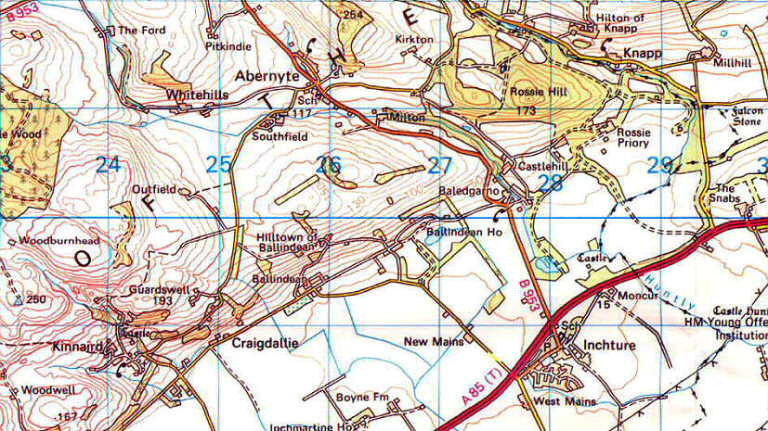
The South Sidlaws village and parish of Abernyte is not so well known as it deserves to be, sitting in its wide, south-facing, hanging valley between the Carse of Gowrie and Strathmore, 9 miles west of Dundee and 2 north-west of Inchture. It is a pleasant place, but to call it a village is almost a misnomer. One gets the impression that the Abernyters are notably fond of walking. For its various sections are all so wide apart as to be extraordinary, scattered over a network of side-roads in the laps of the green hills. All, however, have fine and extensive views, especially south-eastwards through the gap in the hills to the carse and the open sea at the mouth of the Firth of Tay. King's Seat is in this parish, and presides over all, at 1236 feet the highest point of the South Sidlaws, with an ancient chambered cairn and enclosure at its summit.
The major parts of scattered Abernyte lie dotted along the B.953 Inchture to Balbeggie road, threading the very attractive fertile glen, shut in on three sides by green hills. The first we come to, from the south, is the former Free Church and manse, now converted into a large garage establishment, and seeming as odd as must have been the church to be isolated thus. Then, half a mile on, at a road junction, is the Milton and school with some cottages; and a little way farther up still, another group of houses as a cross-roads. A quarter-mile on, built on higher ground, is the largest section of the village, still growing with modern houses. Then, away more than another half-mile to the east, passing Abernyte House and its rather strangely set-down walled garden, is the very detached Kirkton, with the parish church and a large, whitewashed and fine-looking manse facing out over the sinking braesides to the south, all under the wooded craigs of Rossie Hill.
The church is an old foundation rebuilt in 1736. There is a parish record declaring: "December 4 1664, the whilk day Mr. Andrew Shippert was admitted minister of Aberneit, by Mr. Robert White, minister at Instur, being authorized by my Lord Bishop of Dunkelden to that effect. Collected that day 7 shillings two pennies." The said bishop was himself contemporaneously minister of St. Madoes parish, along the Carse, nimbly straddling circumstances. There are some old tombs in the graveyard.
Abernyte parish boasts sundry antiquities. There are not a few cairns, one of which used to stand in the manse glebe, with bones found under it. These were said to commemorate a battle between the Grays of Fowlis and the Boyds of Pitkindie, just up the road-though it seems much more likely that they are of prehistoric origin. On a hill called Glenny Law, as well as cairns, is said to be a stone circle of seven stones; and at Stockmuir, one of nine. On an ancient map north of Ballairdie, were marked the remains of a castle named Carquhannan, though locally called Balchuinnie, with a spring near by designated the King's Well. This may well have been Scotland's only King Edgar, for a mile or so down the road southwards is the rather unusual hamlet of Baledgarn (pro nounced Bal-egger-ny) bearing the name of Edgar, 4th son of Malcolm Canmore, anointed king in 1001, and who built a castle on the hill just above here, still called Castlehill. Boethius declares it was "foundit by Edgar in Gowry, wha gat certane landis fra the Erle of Gowry, and annexit his name to the castle".
Baledgarno, however, as a village, only dates from the early 19th century; and an attractive place it is, lying on either side of a falling burn just to the west of the policy wall of the Rossie Priory estate. But this hamlet did not grow; it was made. The 8th Lord Kinnaird decided to leave Drimmie House, down near the present A.85 road, and build a great new mansion up on a terrace in his splendid park-land, under Rossie Hill, this in 1807. Unfortunately the old village of Rossie seems to have offended his sensibilities. Not that it cluttered the site, being fully half a mile away to the east, and not very evident from the new palace. But these were the days of great lords and large gestures, and for better or worse the village was bodily removed a mile to the west. Oddly enough, the old market cross was left behind, and still stands in lonely splendour by its burnside in the open parkland, with the former village church, now the family burial-chapel, on the yew-clad hillock behind. The cross has a four-stepped plinth, and on top of its shaft is a highly unusual finial in the form of four lions and unicorns back-to-back, beneath inscribed R.H. and K.G. 1746. The significance of these initials is not clear. A single standing-stone projects from the turf a few yards to the west, which also must have been in the village street. The Kinnairds' chapel is kept in good repair, and within, amongst the memorials of the family, is a splendid Celtic cross-slab, highly decorative, with horsemen, animals and intricate ribbon ornamentation. These cross-slabs, another of which stands at St. Madoes Church, 9 miles to the south-west, date from the period A.D. 800-1000, it is thought, and are of Celtic-Pictish origin.
Rossie Priory itself, standing in a magnificent position in finely-rising parkland, is still a most handsome mansion although greatly reduced in size in recent years. It contains many treasures, and remains the seat of the Lords Kinnaird. Highly unusual is the pend which passes through the middle of the house, so that a visitor may drive right through from one side and driveway to another. The predecessor of this great house and Drimmie also, is the red-stone, late 16th century castle of Moncur, which still stands in a ruinous state, within the estate, about a mile to the south, near an attractive pond and visible from the main A.85 road. It has been a fine fortalice, liberally equipped with gun-loops, built on the Z-plan, with a notable hall fireplace and great chimney-stack therefor.
To the east of Rossie, in a field, is another monolith called the Falcon Stone, allegedly one more of those landmarks which the Hay's hawk alighted upon, after the Battle of Luncarty in 990, in its over-flying of the lands the Hays were to gain as reward for their part in the battle-an active and useful bird. Probably, however, the stone has a much earlier significance.
Behind wooded Rossie Hill is the estate hamlet of Knapp, tucked away in a quite secret valley threaded by a side-road. Here is an unusual feature - a 17th century doocote turned into a cottage. Farther north, on the high ground of Dron, is a Pictish fort on the hilltop. And to the east, at the farm of Dron, are the ruins of a 12th century chapel, formerly attached to Coupar Angus Abbey. Only two gables remain, by the burnside, but that to the west has a fine, tall pointed archway.
North of this point, the land climbs to a high and lonely moorland plateau area, part of Longforgan parish, around the 65o-foot contour, scattered with ancient Scots pines and other wind-blown trees, gorse and heather. In its remote centre is the small loch of Redmyre. It is hard to believe that this lofty wilderness is only 7 miles from busy Dundee.
INCHTURE
Just south of the busy A.85 dual-carriageway between Perth and Dundee, 7 miles west of the latter, is the village of Inchture. As its name implies, once an island in the flooded Carse of Gowrie. It must have been a very low island, for its eminence is hardly noticeable in the level flats; indeed the church and churchyard are alleged to be built up 6 to 8 feet artificially, presumably to afford suitable burial facilities in the early days. Tuir, in Gaelic means a dirge, or lament for the dead, and it may be that the original inch got its name thus; although another claimed derivation is innis-t-ear, the island to the east. Today there is a neat red-stone estate-type village, with church, school, hotel and a shop or two, all under an avenue of tall old trees, and rather attractive.
The parish church is distinctly ambitious for so small a community; but the parish itself is fairly large, and now incorporates the former parish of Rossie. The Gothic building dates from 1834, and is unusual in having handsome red ashlar stone at front and sides, but only harling at the rear, an economy the present author has not seen elsewhere in a church. It stands amongst many ancient gravestones, with another Kinnaird vault below the building, additional to that at the old chapel at Rossie.
Most of the antiquities of this parish are in the higher ground of the Rossie area, and dealt with under that name. A battle was allegedly fought near the ruined castle of Moncur, across the main road to the north of the village, in 728, when in a civil war Hungus, or Angus, defeated Nectan and gained the leadership of the Picts.
The Parish covers 5330 acres, of which no fewer than 1200 are described as foreshore or have been reclaimed from the firth. A long dead-straight road of 2 miles runs down over the rich flat cornlands to salt water at Powgavie. Pow or poll is the name given to the sluggish streams or stanks which drain the carse. At Powgavie there was formerly a harbour, once quite important, where there was a hamlet and alehouse, all now gone and only a sea of reeds and rushes remaining. At low tide, the Powgavie Burn winds its way out through the mud-flats and sandbanks of Dog Bank for almost three miles. Some of the farms in these fertile carselands have odd names-such as Maggotland, Mammiesroom, Waterbutts and Unthank. At Grange, 3 miles south-west of Inchture, there is a sizeable community, amongst scattered orchards and broiler-houses. Inchture district is famous for the cultivation of strawberries. All this Carse of Gowne, of course, claims the title of the Garden of Scotland.
KINNAIRD
There are many Kinnairds in Scotland, the name meaning merely the head of the height. But there is only one actual parish and village of the name. It is one of those picturesque little communities which nestle in the south-facing folds of the Carse Braes, overlooking the plain of Tay and Gowrie, standing about two miles west of Inchture. Here there is a quite delightful little village, with parish church and manse, all overlooked and dominated by a tall castle. The parish rises from the 5o-foot level in the carselands almost to the 1000-foot contour at Blacklaw; so there is much of climbing, green hillsides, hanging woods and splendid vistas. There was formerly another village at Pitmiddle, much higher on the Braes, to the north-east about a mile; but this, like a number of other Gowrie villages has dwindled into obscurity with the draining of the level plain, and the roads in consequence tending to abandon the heights. There is still a large wood of that name.
Kinnaird village itself sits on broken hillside terraces beside the ravine of its own burn, facing south amongst its orchards, with no village street or scheme of lay-out, but no less attractive therefor. Some of the cottages still retain their thatched roofs. The church dates only from 1815, and is a plain but pleasing building of red stone, with a watch-house; presumably it was necessary to counter the activities of body-snatchers even in this peaceful and arcadian spot. The Threipland of Fingask burial-place flanks the church door.
Kinnaird Castle, not to be confused with the much larger seat of that name in Angus, is much more in evidence here than is usual, not hidden away in any large wooded estate but soaring impressively on an open green knoll above the village, still occupied and in good order. It is an interesting and dramatic place, a tall, red-stone keep of the 15th century with earlier nucleus, thick-walled, with a small projecting tower or buttress at one corner, which is not a stair-tower, as it seems, and highly unusual, its summit forming a watch-chamber at high parapet level. Another unusual feature is the two-storeyed 17th century addition to the east-for this is not actually attached to the keep. It contains an old kitchen with an enormous arched fireplace 13 feet wide by 6 deep, with an outside service window, evidently for viands to be pushed through for the castle's family. Hot dishes cannot have been a speciality at Kinnaird.
It is claimed that one Randolph Rufus obtained, from William the Lyon, these lands in 1170; and his descendants took their name therefrom. One, Sir Richard Kinnaird of that Ilk, married his son Reginald to the heiress of Sir John Kirkcaldy of Inchture, and so gained these neighbouring carselands, in the time of Robert III. Just when the Kinnairds moved to live at Moncur Castle, nearer Inchture (now itself a ruin and abandoned by them for Rossie Priory in the vicinity) is not clear. But Sir Patrick Threipland, 1st Baronet of Fingask, bought Kinnaird in the 17th century. Just beforehand, in 1617, James VI on a rare return visit to Scotland, spent some days hunting from here. Later the castle became ruinous, but happily was restored towards the close of the last century.
(Taken from book: The Queen's Scotland - The Heartland by Nigel Tranter)